Sombor
Sombor Град Сомбор | ||
|---|---|---|
City | ||
| City of Sombor | ||
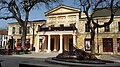
 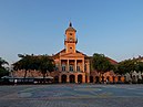     From top: Town hall, Old Town Hall, Rome Catholic Church, Preparandija building, Krušper's palace, Main pedestrian street | ||
| ||
 Sombor Location of the city of Sombor in Serbia | ||
| Coordinates: 45°47′N 19°07′E / 45.783°N 19.117°E / 45.783; 19.117Coordinates: 45°47′N 19°07′E / 45.783°N 19.117°E / 45.783; 19.117 | ||
| Country | ||
| Province | ||
| District | West Bačka | |
| City status | 17 February 1749 | |
| Settlements | 16 | |
| Government | ||
| • Mayor | Dušanka Golubović | |
| Area [1] | ||
| Area rank | 7th in Serbia | |
| • Urban | 289.23 km2 (111.67 sq mi) | |
| • Administrative | 1,216.80 km2 (469.81 sq mi) | |
| Elevation | 90 m (300 ft) | |
| Population (2011 census)[2] | ||
| • Rank | 16th in Serbia | |
| • Urban | 47,623 | |
| • Urban density | 160/km2 (430/sq mi) | |
| • Administrative | 85,903 | |
| • Administrative density | 71/km2 (180/sq mi) | |
| Time zone | UTC+1 (CET) | |
| • Summer (DST) | UTC+2 (CEST) | |
| Postal code | 25000 | |
| Area code | +381 25 | |
| Car plates | SO | |
| Website | www.sombor.rs | |

Sombor (Serbian Cyrillic: Сомбор, pronounced [sɔ̂mbɔr]; Hungarian: Zombor; Rusyn: Зомбор / Zombor) is a city and the administrative center of the West Bačka District in the autonomous province of Vojvodina, Serbia. The city has a total population of 47,623 (as of 2011[update]), while its administrative area (including neighboring villages) has 85,903 inhabitants.
Contents
1 Name and etymology
2 History
3 Geography
3.1 Climate
4 Demographics
4.1 Ethnic groups in the Sombor administrative area
4.1.1 Inhabited settlements
5 Culture
5.1 Buildings and architecture
5.2 Sports
6 Economy
7 Local media
7.1 Newspapers
7.2 TV stations
7.3 Radio stations
7.4 Internet media
8 Twin cities
9 Transportation
9.1 Buses
9.2 Rail
9.3 Air
10 Notable residents
11 See also
12 References
13 External links
Name and etymology
In Serbian, the city is known as Sombor (Сомбор), in Hungarian and German as Zombor, in Croatian and Bunjevac as Sombor, in Rusyn as Zombor (Зомбор), and in Turkish as Sonbor.
The older Hungarian name for the city was Czoborszentmihály. The name originates from the Czobor family, who were the owners of this area in the 14th century (The family name came from the Slavic name Cibor). The Serbian name for the city (Sombor) also came from the family name Czobor, and was first recorded in 1543, although the city was mentioned in historical documents under several more names, such as Samobor, Sambor, Sambir, Sonbor, Sanbur, Zibor, and Zombar.
An unofficial Serbian name used for the city is Ravangrad (Раванград), which means "flat town" in English.
History

Serbian Orthodox church

Main pedestrian street
The first historical record about the city is from 1340. The city was administered by the Kingdom of Hungary until the 16th century, when it became part of the Ottoman Empire. During the establishment of Ottoman authority, local Hungarian population left from this region. During the Ottoman administration, the city was populated mostly by ethnic Serbs.[3] It was called "Sonbor" during Ottoman administration and was a kaza centre in Sanjak of Segedin at first in Budin Province till 1596, and then in Eğri Province between 1596 and 1687.
In 1665, a well-known traveller, Evlia Celebi, visited Sombor and wrote: "All the folk (in the city) are not Hungarian, but Wallachian-Christian (Serb[3]). These places are something special; they do not belong to Hungary, but are a part of Bačka and Wallachia. Most of the inhabitants are traders, and all of them wear frontiersmen clothes; they are very polite and brave people." According to Celebi, the city had 200 shops, 14 mosques and about 2,000 houses.
Since 12 September 1687, the city was under Habsburg administration, and was included into the Habsburg Military Frontier. Ottomans attempted to recapture it during Battle of Zenta in 11 September 1697. However their attack was repulsed. In 1717, the first Orthodox elementary school was opened. Five years later a Roman Catholic elementary school was opened as well. In 1745 Sombor was excluded from the Military Frontier and was included into Bacsensis County. In 1749 Sombor gained royal free city status. In 1786, the city became the seat of Bacsensis-Bodrogiensis County. According to 1786 data, the population of the city numbered 11,420 people, mostly Serbs.
According to the 1843 data, Sombor had 21,086 inhabitants, of whom 11,897 were Orthodox Christians, 9,082 Roman Catholics, 56 Jewish, and 51 Protestants. The main language spoken in the city at this time was Serbian, and the second largest language was German. In 1848/1849, Sombor was part of the Serbian Vojvodina, a Serb autonomous region within Austrian Empire, while between 1849 and 1860, it was part of the Voivodeship of Serbia and Temes Banat, a separate Austrian crown land. Sombor was a seat of the district within voivodship. After the abolishment of this crown land, Sombor again became the seat of the Bacsensis-Bodrogiensis (Bács-Bodrog, Bačka-Bodrog) County.
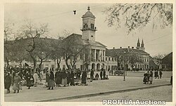
Holy Trinity Square in 1941
According to the 1910 census, the population of Sombor was 30,593 people, of whom 11,881 spoke the Serbian language, 10,078 spoke the Hungarian language, 6,289 spoke the Bunjevac language, 2,181 spoke the German language.
In 1918, Sombor became part of the Kingdom of Serbs, Croats and Slovenes (later known as the Kingdom of Yugoslavia). Between 1918 and 1922 it was part of Bačka County, between 1922 and 1929 part of Bačka Oblast, and between 1929 and 1941 part of Danube Banovina.
In 1941, city was occupied by the Axis powers and annexed by Hungary. Many prominent citizen from Serbian community were interned and later executed. In 1944, Yugoslav partisans and Soviet Red Army expelled Axis forces from the city. Since 1944, Sombor was part of the Autonomous Province of Vojvodina of the new Socialist Yugoslavia and (since 1945) socialist Serbia. Today, Sombor is the seat of the West Bačka District.
Geography
Climate
Climate in this area has mild differences between highs and lows, and there is adequate rainfall year-round. The Köppen Climate Classification subtype for this climate is "Cfb" (Marine West Coast Climate/Oceanic climate).[4]
| Climate data for Sombor (1981–2010, extremes 1961–2010) | |||||||||||||
|---|---|---|---|---|---|---|---|---|---|---|---|---|---|
| Month | Jan | Feb | Mar | Apr | May | Jun | Jul | Aug | Sep | Oct | Nov | Dec | Year |
| Record high °C (°F) | 19.3 (66.7) | 21.3 (70.3) | 27.6 (81.7) | 29.5 (85.1) | 35.1 (95.2) | 37.1 (98.8) | 40.3 (104.5) | 39.5 (103.1) | 35.7 (96.3) | 29.4 (84.9) | 25.7 (78.3) | 20.7 (69.3) | 40.3 (104.5) |
| Average high °C (°F) | 3.6 (38.5) | 6.3 (43.3) | 12.0 (53.6) | 17.8 (64) | 23.3 (73.9) | 26.1 (79) | 28.5 (83.3) | 28.5 (83.3) | 23.7 (74.7) | 18.1 (64.6) | 10.2 (50.4) | 4.5 (40.1) | 16.9 (62.4) |
| Daily mean °C (°F) | −0.1 (31.8) | 1.4 (34.5) | 6.2 (43.2) | 11.6 (52.9) | 17.1 (62.8) | 20.2 (68.4) | 21.9 (71.4) | 21.3 (70.3) | 16.5 (61.7) | 11.3 (52.3) | 5.4 (41.7) | 1.1 (34) | 11.2 (52.2) |
| Average low °C (°F) | −3.4 (25.9) | −2.6 (27.3) | 1.2 (34.2) | 5.8 (42.4) | 10.8 (51.4) | 13.8 (56.8) | 15.2 (59.4) | 14.7 (58.5) | 10.7 (51.3) | 6.2 (43.2) | 1.7 (35.1) | −1.8 (28.8) | 6.0 (42.8) |
| Record low °C (°F) | −27.2 (−17) | −26.3 (−15.3) | −20.3 (−4.5) | −5.6 (21.9) | −1.0 (30.2) | 2.0 (35.6) | 7.3 (45.1) | 4.6 (40.3) | −2.2 (28) | −6.9 (19.6) | −18.4 (−1.1) | −23.7 (−10.7) | −27.2 (−17) |
| Average precipitation mm (inches) | 37.3 (1.47) | 29.9 (1.18) | 36.4 (1.43) | 45.2 (1.78) | 60.0 (2.36) | 81.5 (3.21) | 66.2 (2.61) | 53.1 (2.09) | 54.4 (2.14) | 47.3 (1.86) | 53.7 (2.11) | 47.4 (1.87) | 612.4 (24.11) |
| Average precipitation days (≥ 0.1 mm) | 11 | 10 | 10 | 12 | 12 | 13 | 10 | 9 | 10 | 9 | 11 | 13 | 128 |
| Average snowy days | 7 | 6 | 3 | 0 | 0 | 0 | 0 | 0 | 0 | 0 | 2 | 6 | 24 |
| Average relative humidity (%) | 84 | 78 | 70 | 66 | 64 | 65 | 64 | 66 | 71 | 75 | 82 | 86 | 72 |
| Mean monthly sunshine hours | 62.2 | 97.5 | 147.6 | 191.8 | 244.1 | 259.5 | 290.3 | 274.3 | 197.1 | 152.5 | 80.4 | 53.0 | 2,050.4 |
| Source: Republic Hydrometeorological Service of Serbia[5] | |||||||||||||
Demographics
| Historical population | ||
|---|---|---|
| Year | Pop. | ±% p.a. |
| 1948 | 90,477 | — |
| 1953 | 92,583 | +0.46% |
| 1961 | 96,191 | +0.48% |
| 1971 | 98,080 | +0.19% |
| 1981 | 99,168 | +0.11% |
| 1991 | 96,105 | −0.31% |
| 2002 | 97,263 | +0.11% |
| 2011 | 85,903 | −1.37% |
| Source: [6] | ||
According to the last official census done in 2011, the city of Sombor has 85,903 inhabitants.
Ethnic groups in the Sombor administrative area
The population of the Sombor administrative area (as of 2011[update]) is composed of:[7]
Serbs = 54,370 (63.29%)
Hungarians = 9,874 (11.49%)
Croats = 7,070 (8.23%)
Bunjevci = 2,058 (2.4%)
Roma = 1,015 (1,18%)
Yugoslavs = 852 (0.99%)- Others and undeclared = 10,664 (12.41%)
The population of the Sombor town itself is composed of (2011 census):[7]
Serbs = 32,180 (67.57%)
Croats = 2,863 (6.01%)
Hungarians = 2,851 (5.99%)
Bunjevci = 1,629 (3.42%)
Yugoslavs = 594 (1.25%)
Montenegrins = 475 (1.00%)- Others and undeclared = 7,031 (14.77%)
Settlements with Serb ethnic majority (in 2002) are: Sombor, Aleksa Šantić, Gakovo, Kljajićevo, Kolut, Rastina, Riđica, Stanišić, Stapar, and Čonoplja. Settlements with Croat/Šokac ethnic majority (in 2002) are: Bački Breg and Bački Monoštor. Settlements with Hungarian ethnic majority (in 2002) are: Bezdan, Doroslovo, and Telečka. Ethnically mixed settlement with relative Hungarian majority is Svetozar Miletić.
Inhabited settlements
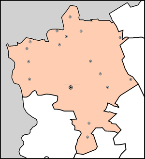
Municipality
of Sombor
●

Neighborhoods of urban Sombor
The city administrative area of Sombor includes following villages:
- Aleksa Šantić
- Bački Breg
- Bački Monoštor
- Bezdan
- Gakovo
- Doroslovo
- Kljajićevo
- Kolut
- Rastina
- Riđica
- Svetozar Miletić
- Stanišić
- Stapar
- Telečka
- Čonoplja
Smaller and suburban settlements include
- Bukovački Salaši
- Rančevo
- Kruševlje
- Bilić
- Lugomerci
- Žarkovac
- Šaponje
Culture

Building of former Sombor Norma where first civil school in Serbian language was established.

Carmelite monastery and church in the centre of the town.
Sombor is famous for its greenery, cultural life and beautiful 18th and 19th century center. The most important cultural institutions are the National Theater, the Regional Museum, the Modern Art Gallery, the Milan Konjović Art Gallery, the Teacher's College, the Serbian Reading House, and the Grammar School. Teacher's College, founded in 1778, is the oldest college in Serbia and the region.
Sombor's rich history includes the oldest institution for higher education in the Serbian language. The town is also home of numerous minority organisations, including the Hungarian Pocket Theater Berta Ferenc, the Croatian Society Vladimir Nazor, the Jewish Municipality and several other smaller organisations including German and Romani clubs.
There are two monasteries in this city:
Sombor Orthodox Monastery, founded in 1928–1933
Carmelite Catholic monastery, founded in 1904
Buildings and architecture

Županija building housing city and city administration

The old town hall of Sombor and the Holy Trinity Square
Sombor theater building

Sombor main street with the water fountain

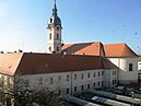
Catholic church in Sombor


Sports
Radnički Sombor is the main football club from the city.
Nikola Jokić is an NBA player who currently plays for the Denver Nuggets.
Filip Krajinović is professional tennis player.
Economy
The following table gives a preview of total number of employed people per their core activity (as of 2016):[8]
| Activity | Total |
|---|---|
| Agriculture, forestry and fishing | 1,140 |
| Mining | - |
| Processing industry | 4,386 |
| Distribution of power, gas and water | 233 |
| Distribution of water and water waste management | 320 |
| Construction | 598 |
| Wholesale and retail, repair | 3,157 |
| Traffic, storage and communication | 1,056 |
| Hotels and restaurants | 668 |
| Media and telecommunications | 201 |
| Finance and insurance | 360 |
| Property stock and charter | 49 |
| Professional, scientific, innovative and technical activities | 609 |
| Administrative and other services | 541 |
| Administration and social assurance | 1,438 |
| Education | 1,646 |
| Healthcare and social work | 2,120 |
| Art, leisure and recreation | 274 |
| Other services | 346 |
| Total | 19,145 |
Local media
Newspapers
- Somborske novine[9]
TV stations
- K-54
- Spektar[10]
- RTV Sreće[11]
Radio stations
- Radio Marija (95,7)
- Radio Sombor (97.5)[12]
- Radio Fortuna (106.6)
Internet media
- SOinfo.org[13]
Twin cities
Twin cities:
 Baja, Hungary
Kispest, Hungary
 Veles, Macedonia
Regional cooperation:
 Osijek, Croatia
 Tuzla, Bosnia and Herzegovina
Vukovar, Croatia
Transportation
Buses
Buses offer direct connections to major Serbian cities including Belgrade, Novi Sad and Subotica, as well as many regional towns. Among the companies operating in the area is Severtrans.
Rail
Sombor is linked by direct rail links to Novi Sad and Subotica, among others.
Air
The city houses Sombor Airport.
Notable residents
Sándor Gombos (1895-1968), Olympic champion fencer
Nikola Jokic, Professional Basketball player, currently with the Denver Nuggets
See also
- List of cities in Serbia
- List of cities, towns and villages of Vojvodina
- West Bačka District
References
^ "Municipalities of Serbia, 2006". Statistical Office of Serbia. Retrieved 2010-11-28..mw-parser-output cite.citation{font-style:inherit}.mw-parser-output q{quotes:"""""""'""'"}.mw-parser-output code.cs1-code{color:inherit;background:inherit;border:inherit;padding:inherit}.mw-parser-output .cs1-lock-free a{background:url("//upload.wikimedia.org/wikipedia/commons/thumb/6/65/Lock-green.svg/9px-Lock-green.svg.png")no-repeat;background-position:right .1em center}.mw-parser-output .cs1-lock-limited a,.mw-parser-output .cs1-lock-registration a{background:url("//upload.wikimedia.org/wikipedia/commons/thumb/d/d6/Lock-gray-alt-2.svg/9px-Lock-gray-alt-2.svg.png")no-repeat;background-position:right .1em center}.mw-parser-output .cs1-lock-subscription a{background:url("//upload.wikimedia.org/wikipedia/commons/thumb/a/aa/Lock-red-alt-2.svg/9px-Lock-red-alt-2.svg.png")no-repeat;background-position:right .1em center}.mw-parser-output .cs1-subscription,.mw-parser-output .cs1-registration{color:#555}.mw-parser-output .cs1-subscription span,.mw-parser-output .cs1-registration span{border-bottom:1px dotted;cursor:help}.mw-parser-output .cs1-hidden-error{display:none;font-size:100%}.mw-parser-output .cs1-visible-error{font-size:100%}.mw-parser-output .cs1-subscription,.mw-parser-output .cs1-registration,.mw-parser-output .cs1-format{font-size:95%}.mw-parser-output .cs1-kern-left,.mw-parser-output .cs1-kern-wl-left{padding-left:0.2em}.mw-parser-output .cs1-kern-right,.mw-parser-output .cs1-kern-wl-right{padding-right:0.2em}
^ "2011 Census of Population, Households and Dwellings in the Republic of Serbia: Comparative Overview of the Number of Population in 1948, 1953, 1961, 1971, 1981, 1991, 2002 and 2011, Data by settlements" (PDF). Statistical Office of Republic Of Serbia, Belgrade. 2014. ISBN 978-86-6161-109-4. Retrieved 2014-06-27.
^ ab "Историја". 23 January 2017. Retrieved 22 December 2017.
^ "Obziri, Serbia Köppen Climate Classification (Weatherbase)". Weatherbase. Retrieved 22 December 2017.
^ "Monthly and annual means, maximum and minimum values of meteorological elements for the period 1981–2010" (in Serbian). Republic Hydrometeorological Service of Serbia. Retrieved February 25, 2017.
^ "2011 Census of Population, Households and Dwellings in the Republic of Serbia" (PDF). stat.gov.rs. Statistical Office of the Republic of Serbia. Retrieved 11 December 2017.
^ ab "Population by ethnicity – Sombor". Statistical Office of the Republic of Serbia (SORS). Retrieved 4 March 2013.
^ "ОПШТИНЕ И РЕГИОНИ У РЕПУБЛИЦИ СРБИЈИ, 2017" (PDF). stat.gov.rs (in Serbian). Statistical Office of the Republic of Serbia. Retrieved 16 March 2018.
^ User, Super. "Somborske novine - Početna". www.somborskenovine.co.rs. Retrieved 22 December 2017.
^ "Archived copy". Archived from the original on 23 November 2010. Retrieved 14 November 2010.CS1 maint: Archived copy as title (link)
^ "РТВ СРЕЋЕ СОМБОР & TV SREĆE SOMBOR & Radio Televizija Srece Sombor "TV SOMBOR" UŽIVO". rtvsrece.com. Retrieved 22 December 2017.
^ http://www.somborski.net, Agencija za marketing SOinfo - Zoran Hajtl -. "Radio Sombor- Somborske vesti". www.radiosombor.co.rs. Retrieved 22 December 2017.
^ "SOinfo.org – Sombor 24/7". www.soinfo.org. Retrieved 22 December 2017.
External links
| Wikimedia Commons has media related to Sombor. |
Wikisource has the text of the 1911 Encyclopædia Britannica article Zombor. |
- Official website of the city of Sombor
- www.soinfo.org
- www.sombor.org.rs
- Map of Sombor
Cities, towns and villages in the West Bačka District | ||
|---|---|---|
| Sombor |
|  |
| Apatin |
| |
| Kula |
| |
| Odžaci |
| |
bold are municipalities or cities | ||
Municipalities and cities of Serbia | ||||||||||||
|---|---|---|---|---|---|---|---|---|---|---|---|---|
| ||||||||||||
| ||||||||||||
| ||||||||||||
| ||||||||||||
| ||||||||||||


Authority control |
|
|---|


