Central Coast (California)
Central Coast | |
|---|---|
Region | |
 South Coast of Santa Barbara County | |
 Pismo Beach in San Luis Obispo County | |
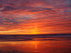
 Sunset at Salinas River State Beach in Monterey County | |
| Country | |
| State | |
| Population | 2,249,558 (All 6 counties combined) |
The Central Coast is an area of California, United States, roughly spanning the coastal region between Point Mugu and Monterey Bay. It lies northwest of Los Angeles County and south of San Francisco and San Mateo counties.[1] Six counties make up the Central Coast: from south-to north, Ventura, Santa Barbara, San Luis Obispo, Monterey, San Benito, and Santa Cruz.[2][3]
The Central Coast is the location of the Central Coast American Viticultural Area.
Note: the geographic center of the California coast is North of Santa Cruz, near Año Nuevo State Park. [4]
Contents
1 History
2 Overview
3 Population
3.1 Counties by population
4 Travel
5 See also
6 References
7 External links
History
The Central Coast area was originally inhabited by Chumash and other Native American people since at least 10,000 BC. Many of these communities were coastal, where the people utilized marine resources and dwelt near freshwater inflows to the Pacific Ocean. For example, there were significant communities near the mouth of Morro Creek and Los Osos Creek.[5]
Juan Rodríguez Cabrillo visited the Central Coast, landing in Santa Barbara County in 1542, having sailed from the south.[6]
Overview

Central Californian Coastline, Big Sur
The region is known primarily for agriculture and tourism. Major crops include wine grapes, lettuce, strawberries, and artichokes. The Salinas Valley is one of the most fertile farming regions in the United States. Tourist attractions include Cannery Row in Monterey, the Monterey Bay Aquarium, the theatres, galleries and white sand beaches of Carmel-by-the-Sea, the golf courses of Pebble Beach and the Monterey Peninsula, the rugged coastline of Big Sur and Hearst Castle in San Simeon. Further south is Morro Rock and the port city of Morro Bay, which is adjacent to college town San Luis Obispo. The Santa Ynez Valley has become a hotbed for wine tasting, with towns such as Buellton, Los Olivos, and Santa Ynez growing in popularity in recent years. It also is home to the Central Coast Film Society,[7] which celebrates filmmakers, cinema and media arts that are from the region, also known as "Hollywood's Backyard."
The area is not densely populated. The largest city in the region is Oxnard in Ventura County, with a population estimated at 203,007 in 2013.[8]University of California campuses are found in Santa Barbara and Santa Cruz, near the south and north edges of the region respectively. California State University, Monterey Bay, founded in 1994, uses facilities donated when Fort Ord was converted from military to civilian uses. California Polytechnic State University, in San Luis Obispo, was founded in 1901. California State University Channel Islands opened in Camarillo in 2002, as the 23rd campus in the California State University system.
Population
The six counties that make up the Central Coast region had an estimated population of 2,327,344 in 2014,[9] about 5% more than the population of New Mexico.
Counties by population
| County | FIPS code[10] | County seat[11] | Established[11] | Formed from | Etymology[12] | Population[9] | Area[11] | Map |
|---|---|---|---|---|---|---|---|---|
Ventura County | 111 | Ventura | 1872 | Santa Barbara | The city of Ventura, itself an abbreviation of San Buenaventura, Spanish for St. Bonaventure. | 7005846178000000000♠846,178 | 7003184600000000000♠1,846 sq mi (7003478100000000000♠4,781 km2) | 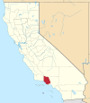 |
Santa Barbara County | 083 | Santa Barbara | 1850 | Original | The city of Santa Barbara, itself Spanish for Saint Barbara. | 7005440668000000000♠440,668 | 7003273800000000000♠2,738 sq mi (7003709100000000000♠7,091 km2) | 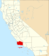 |
Monterey County | 053 | Salinas | 1850 | Original | Monterey Bay, itself a Spanish portmanteau of monte ("hill") and rey ("king"). | 7005431344000000000♠431,344 | 7003332200000000000♠3,322 sq mi (7003860400000000000♠8,604 km2) |  |
San Luis Obispo County | 079 | San Luis Obispo | 1850 | Original | The city of San Luis Obispo, itself Spanish for Saint Louis, the Bishop. | 7005282887000000000♠282,887 | 7003330400000000000♠3,304 sq mi (7003855700000000000♠8,557 km2) |  |
Santa Cruz County | 087 | Santa Cruz | 1850 | Original | The city of Santa Cruz, itself Spanish for holy cross | 7005271804000000000♠271,804 | 7002446000000000000♠446 sq mi (7003115500000000000♠1,155 km2) |  |
San Benito County | 069 | Hollister | 1874 | Monterey | Saint Benedict (San Benedicto in Spanish; Benito is the diminutive of Benedicto). | 7004582670000000000♠58,267 | 7003138900000000000♠1,389 sq mi (7003359700000000000♠3,597 km2) |  |
Travel
Travel is almost entirely by private automobile. Because of its position roughly halfway between the major cities of Los Angeles and San Francisco, San Luis Obispo is home to America's first motel. The major highway is U.S. Route 101, which runs north-south from Los Angeles, through most of the major communities of the Central Coast, to San Francisco. State Route 1, a smaller but much more scenic route, connects the coastal communities, running through San Simeon, Morro Bay, and Big Sur. Amtrak maintains train service with the Coast Starlight and Pacific Surfliner routes along the Union Pacific Railroad Coast Line that also transports freight. There are no major airports, although Monterey, Santa Barbara, Santa Maria and San Luis Obispo have regional airports with commuter service. Greyhound buses serve most of the region.
Monterey-Salinas Transit (MST) operates bus services throughout Monterey County as far south as Big Sur on the coast and King City in the Salinas Valley. MST also offers connection service to San Jose Diridon Station, downtown Santa Cruz, and Paso Robles and Templeton in Northern San Luis Obispo County via regional routes. Santa Cruz Metro Offers services within Santa Cruz County, including connections to San Jose and San Jose State and connection to MST service in Watsonville, heading south to Salinas.
See also
- Coastal California
- Big Sur
- Salinas Valley
- Monterey Peninsula
- Monterey county attractions
- Mission County (proposed)
- Hearst Castle
- Avila Beach
- Carmel-by-the-Sea
- California State Route 1
- Wine Regions
References
^ California Central Coast Tourism. Centralcoast-tourism.com. Retrieved on 2013-10-01.
^ "Archived copy" (PDF). Archived from the original (PDF) on 2014-10-24. Retrieved 2014-10-18.CS1 maint: Archived copy as title (link) .mw-parser-output cite.citation{font-style:inherit}.mw-parser-output q{quotes:"""""""'""'"}.mw-parser-output code.cs1-code{color:inherit;background:inherit;border:inherit;padding:inherit}.mw-parser-output .cs1-lock-free a{background:url("//upload.wikimedia.org/wikipedia/commons/thumb/6/65/Lock-green.svg/9px-Lock-green.svg.png")no-repeat;background-position:right .1em center}.mw-parser-output .cs1-lock-limited a,.mw-parser-output .cs1-lock-registration a{background:url("//upload.wikimedia.org/wikipedia/commons/thumb/d/d6/Lock-gray-alt-2.svg/9px-Lock-gray-alt-2.svg.png")no-repeat;background-position:right .1em center}.mw-parser-output .cs1-lock-subscription a{background:url("//upload.wikimedia.org/wikipedia/commons/thumb/a/aa/Lock-red-alt-2.svg/9px-Lock-red-alt-2.svg.png")no-repeat;background-position:right .1em center}.mw-parser-output .cs1-subscription,.mw-parser-output .cs1-registration{color:#555}.mw-parser-output .cs1-subscription span,.mw-parser-output .cs1-registration span{border-bottom:1px dotted;cursor:help}.mw-parser-output .cs1-hidden-error{display:none;font-size:100%}.mw-parser-output .cs1-visible-error{font-size:100%}.mw-parser-output .cs1-subscription,.mw-parser-output .cs1-registration,.mw-parser-output .cs1-format{font-size:95%}.mw-parser-output .cs1-kern-left,.mw-parser-output .cs1-kern-wl-left{padding-left:0.2em}.mw-parser-output .cs1-kern-right,.mw-parser-output .cs1-kern-wl-right{padding-right:0.2em}
^ Brent, Jon (13 May 2014). "Covered California enrollment beats projections by wide margin on Central Coast". Kionrightnow.com. Retrieved 7 November 2017.
^ "Coastal Geographic Center of California".
^ Map, The Megalithic Portal and Megalith. "Morro Creek". The Megalithic Portal. Retrieved 7 November 2017.
^ Kathleen Thompson Hill and Gerald Hill (2004) Santa Barbara and the Central Coast: California's Riviera, Globe Pequot, pages
ISBN 0-7627-2810-8
^ Template:Www.centralcoastfilmsociety.org
^ "Oxnard (city) Quick Facts". United States Census Bureau. United States Census Bureau. Archived from the original on 25 August 2012. Retrieved 7 August 2015.
^ ab "Annual Estimates of the Resident Population by Sex, Race, and Hispanic Origin for the United States, States, and Counties: April 1, 2010 to July 1, 2014". United States Census Bureau. Retrieved August 7, 2015.
^ "EPA County FIPS Code Listing". EPA.gov. Retrieved February 23, 2008.
^ abc National Association of Counties. "NACo - Find a county". Archived from the original on June 5, 2008. Retrieved April 30, 2008.
^ Sanchez, Nellie Van de Grift (1914). Spanish and Indian Place Names of California: Their Meaning and Their Romance. San Francisco: A. M. Robertson. OCLC 4268886.
External links
| Wikimedia Commons has media related to California Coast. |
| Wikivoyage has a travel guide for Central Coast (California). |
- Central California Coast Guide with Photos A comprehensive guide to California's Central Coast
- Central Coast California : wine, food & culture news & updates
Coordinates: 35°36′N 121°06′W / 35.6°N 121.1°W / 35.6; -121.1
California Central Coast | ||
|---|---|---|
| Counties |
|  |
| Cities and towns 100k-250k |
| |
| Cities and towns 25k-100k |
| |
| Cities and towns 10k-25k |
| |
| Sub-regions |
| |
Counties in italics sometimes included in the definition of the Central Coast | ||
Sacramento (capital) | ||
| Topics |
|  |
| Regions |
| |
| Metro regions |
| |
| Counties |
| |
| Most populous cities |
| |


