Marshall County, Illinois
Marshall County, Illinois | |
|---|---|
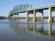 Lacon Bridge in the county seat | |
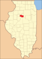
 Location in the U.S. state of Illinois | |
 Illinois's location in the U.S. | |
| Founded | January 19, 1839 |
| Named for | John Marshall |
| Seat | Lacon |
| Largest city | Henry |
| Area | |
| • Total | 399 sq mi (1,033 km2) |
| • Land | 387 sq mi (1,002 km2) |
| • Water | 12 sq mi (31 km2), 2.9% |
| Population | |
| • (2010) | 12,640 |
| • Density | 33/sq mi (13/km2) |
| Congressional district | 18th |
| Time zone | Central: UTC−6/−5 |
| Website | www.marshallcountyillinois.com |
Marshall County is a county located in the U.S. state of Illinois. According to the 2010 census, it had a population of 12,640.[1] Its county seat is Lacon.[2]
Marshall County is part of the Peoria, IL Metropolitan Statistical Area.
Contents
1 History
2 Geography
2.1 Climate and weather
2.2 Major highways
2.3 Adjacent counties
2.4 National protected area
3 Demographics
4 Communities
4.1 Cities
4.2 Villages
4.3 Unincorporated communities
4.4 Townships
5 Politics
6 See also
7 References
History
Marshall County was formed in 1839 out of Putnam County. It was named in honor of John Marshall, Chief Justice of the United States Supreme Court, who died in 1835.[3]
Marshall County at the time of its creation
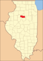
Marshall County in 1843, when its eastern border was extended to bring it to its current size


Geography
According to the U.S. Census Bureau, the county has a total area of 399 square miles (1,030 km2), of which 387 square miles (1,000 km2) is land and 12 square miles (31 km2) (2.9%) is water.[4]
Climate and weather
Lacon, Illinois | ||||||||||||||||||||||||||||||||||||||||||||||||||||||||||||
|---|---|---|---|---|---|---|---|---|---|---|---|---|---|---|---|---|---|---|---|---|---|---|---|---|---|---|---|---|---|---|---|---|---|---|---|---|---|---|---|---|---|---|---|---|---|---|---|---|---|---|---|---|---|---|---|---|---|---|---|---|
| Climate chart (explanation) | ||||||||||||||||||||||||||||||||||||||||||||||||||||||||||||
| ||||||||||||||||||||||||||||||||||||||||||||||||||||||||||||
| ||||||||||||||||||||||||||||||||||||||||||||||||||||||||||||
In recent years, average temperatures in the county seat of Lacon have ranged from a low of 15 °F (−9 °C) in January to a high of 87 °F (31 °C) in July, although a record low of −27 °F (−33 °C) was recorded in January 1999 and a record high of 103 °F (39 °C) was recorded in July 2005. Average monthly precipitation ranged from 1.55 inches (39 mm) in January to 4.20 inches (107 mm) in May.[5]
Major highways
 Interstate 39
 U.S. Highway 51
 Illinois Route 17
 Illinois Route 18
 Illinois Route 26
 Illinois Route 29
 Illinois Route 40
 Illinois Route 89
 Illinois Route 117
 Illinois Route 251
Adjacent counties
Putnam County - north
LaSalle County - east
Woodford County - south
Peoria County - southwest
Stark County - west
Bureau County - northwest
National protected area
Chautauqua National Wildlife Refuge (part)
Demographics
| Historical population | |||
|---|---|---|---|
| Census | Pop. | %± | |
| 1840 | 1,849 | — | |
| 1850 | 5,180 | 180.2% | |
| 1860 | 13,437 | 159.4% | |
| 1870 | 16,956 | 26.2% | |
| 1880 | 15,055 | −11.2% | |
| 1890 | 13,653 | −9.3% | |
| 1900 | 16,370 | 19.9% | |
| 1910 | 15,679 | −4.2% | |
| 1920 | 14,760 | −5.9% | |
| 1930 | 13,023 | −11.8% | |
| 1940 | 13,179 | 1.2% | |
| 1950 | 13,025 | −1.2% | |
| 1960 | 13,334 | 2.4% | |
| 1970 | 13,302 | −0.2% | |
| 1980 | 14,479 | 8.8% | |
| 1990 | 12,846 | −11.3% | |
| 2000 | 13,180 | 2.6% | |
| 2010 | 12,640 | −4.1% | |
| Est. 2016 | 11,939 | [6] | −5.5% |
| U.S. Decennial Census[7] 1790-1960[8] 1900-1990[9] 1990-2000[10] 2010-2013[1] | |||
As of the 2010 United States Census, there were 12,640 people, 5,161 households, and 3,549 families residing in the county.[11] The population density was 32.7 inhabitants per square mile (12.6/km2). There were 5,914 housing units at an average density of 15.3 per square mile (5.9/km2).[4] The racial makeup of the county was 97.1% white, 0.4% Asian, 0.3% black or African American, 0.2% American Indian, 1.1% from other races, and 0.9% from two or more races. Those of Hispanic or Latino origin made up 2.5% of the population.[11] In terms of ancestry, 43.0% were German, 16.7% were Irish, 14.4% were English, 7.2% were Italian, 6.2% were American, and 6.1% were Polish.[12]
Of the 5,161 households, 27.4% had children under the age of 18 living with them, 56.7% were married couples living together, 7.7% had a female householder with no husband present, 31.2% were non-families, and 26.8% of all households were made up of individuals. The average household size was 2.40 and the average family size was 2.88. The median age was 44.8 years.[11]
The median income for a household in the county was $49,116 and the median income for a family was $64,781. Males had a median income of $46,793 versus $28,549 for females. The per capita income for the county was $24,991. About 6.8% of families and 9.5% of the population were below the poverty line, including 11.4% of those under age 18 and 7.0% of those age 65 or over.[13]
Communities
Cities
- Henry
- Lacon
- Toluca
- Wenona
Villages
- Hopewell
- La Rose
- Sparland
- Varna
- Washburn
Unincorporated communities
- Camp Grove
- Hopewell Estates
- La Prairie Center
- Lawn Ridge
- Leeds
- Pattonsburg
- Saratoga Center
- Wilbern
Townships
- Bell Plain
- Bennington
- Evans
- Henry
- Hopewell
- Lacon
- La Prairie
- Richland
- Roberts
- Saratoga
- Steuben
- Whitefield
Politics
In its early days Marshall County was a swing county, voting for winning Whig candidate William Henry Harrison in 1840 but otherwise supporting the Democratic Party until 1852. Its reputation as a swing county was to be sustained with the growth of the Republican Party: it voted for the winning candidate in every election from 1852 to 1912 except 1884 and 1888.
Since World War I, Marshall has generally been a strongly Republican county. Only two Democrats – Franklin D. Roosevelt in 1932 and 1936 plus Lyndon Johnson in 1964 – have gained an absolute majority in Marshall County over the past twenty-six elections, although Bill Clinton won pluralities in both his elections.
| Year | Republican | Democratic | Third parties |
|---|---|---|---|
2016 | 63.3% 3,785 | 29.9% 1,789 | 6.9% 410 |
2012 | 56.1% 3,290 | 41.8% 2,455 | 2.1% 124 |
2008 | 49.5% 3,145 | 48.5% 3,081 | 1.9% 122 |
2004 | 56.7% 3,734 | 42.6% 2,806 | 0.7% 44 |
2000 | 53.2% 3,145 | 43.5% 2,570 | 3.3% 192 |
1996 | 42.9% 2,453 | 46.2% 2,640 | 10.9% 621 |
1992 | 38.4% 2,491 | 43.4% 2,819 | 18.3% 1,186 |
1988 | 56.4% 3,588 | 43.1% 2,742 | 0.6% 37 |
1984 | 62.5% 4,060 | 36.8% 2,386 | 0.7% 47 |
1980 | 64.8% 4,349 | 28.4% 1,903 | 6.8% 459 |
1976 | 60.3% 4,017 | 38.6% 2,570 | 1.1% 75 |
1972 | 67.4% 4,452 | 32.4% 2,141 | 0.1% 9 |
1968 | 58.4% 3,897 | 36.8% 2,455 | 4.9% 325 |
1964 | 47.4% 3,209 | 52.6% 3,561 | |
1960 | 58.1% 4,150 | 41.8% 2,981 | 0.1% 7 |
1956 | 67.9% 4,764 | 32.0% 2,245 | 0.1% 5 |
1952 | 67.4% 4,850 | 32.5% 2,343 | 0.1% 8 |
1948 | 59.9% 3,785 | 39.8% 2,514 | 0.3% 19 |
1944 | 61.7% 4,195 | 38.2% 2,596 | 0.2% 10 |
1940 | 57.2% 4,527 | 42.3% 3,343 | 0.5% 40 |
1936 | 45.7% 3,544 | 53.5% 4,149 | 0.9% 67 |
1932 | 43.1% 3,166 | 56.3% 4,133 | 0.6% 46 |
1928 | 58.7% 4,029 | 41.2% 2,828 | 0.1% 8 |
1924 | 58.4% 3,776 | 28.4% 1,836 | 13.2% 853 |
1920 | 67.6% 3,734 | 28.4% 1,568 | 4.0% 221 |
1916 | 55.8% 3,579 | 40.5% 2,593 | 3.7% 238 |
1912 | 21.0% 790 | 44.7% 1,685 | 34.3% 1,293 |
1908 | 50.1% 1,893 | 45.4% 1,714 | 4.5% 169 |
1904 | 56.0% 2,190 | 39.5% 1,545 | 4.6% 178 |
1900 | 52.8% 2,210 | 45.6% 1,908 | 1.7% 69 |
1896 | 53.3% 2,216 | 45.4% 1,888 | 1.4% 57 |
1892 | 45.0% 1,590 | 51.9% 1,834 | 3.1% 110 |
See also
- National Register of Historic Places listings in Marshall County, Illinois
References
^ ab "State & County QuickFacts". United States Census Bureau. Archived from the original on July 14, 2011. Retrieved July 7, 2014..mw-parser-output cite.citation{font-style:inherit}.mw-parser-output q{quotes:"""""""'""'"}.mw-parser-output code.cs1-code{color:inherit;background:inherit;border:inherit;padding:inherit}.mw-parser-output .cs1-lock-free a{background:url("//upload.wikimedia.org/wikipedia/commons/thumb/6/65/Lock-green.svg/9px-Lock-green.svg.png")no-repeat;background-position:right .1em center}.mw-parser-output .cs1-lock-limited a,.mw-parser-output .cs1-lock-registration a{background:url("//upload.wikimedia.org/wikipedia/commons/thumb/d/d6/Lock-gray-alt-2.svg/9px-Lock-gray-alt-2.svg.png")no-repeat;background-position:right .1em center}.mw-parser-output .cs1-lock-subscription a{background:url("//upload.wikimedia.org/wikipedia/commons/thumb/a/aa/Lock-red-alt-2.svg/9px-Lock-red-alt-2.svg.png")no-repeat;background-position:right .1em center}.mw-parser-output .cs1-subscription,.mw-parser-output .cs1-registration{color:#555}.mw-parser-output .cs1-subscription span,.mw-parser-output .cs1-registration span{border-bottom:1px dotted;cursor:help}.mw-parser-output .cs1-hidden-error{display:none;font-size:100%}.mw-parser-output .cs1-visible-error{font-size:100%}.mw-parser-output .cs1-subscription,.mw-parser-output .cs1-registration,.mw-parser-output .cs1-format{font-size:95%}.mw-parser-output .cs1-kern-left,.mw-parser-output .cs1-kern-wl-left{padding-left:0.2em}.mw-parser-output .cs1-kern-right,.mw-parser-output .cs1-kern-wl-right{padding-right:0.2em}
^ "Find a County". National Association of Counties. Retrieved 2011-06-07.
^ Gannett, Henry (1905). The Origin of Certain Place Names in the United States. U.S. Government Printing Office. p. 200.
^ ab "Population, Housing Units, Area, and Density: 2010 - County". United States Census Bureau. Retrieved 2015-07-12.
^ ab "Monthly Averages for Lacon, Illinois". The Weather Channel. Retrieved 2011-01-27.
^ "Population and Housing Unit Estimates". Retrieved June 9, 2017.
^ "U.S. Decennial Census". United States Census Bureau. Retrieved July 7, 2014.
^ "Historical Census Browser". University of Virginia Library. Retrieved July 7, 2014.
^ "Population of Counties by Decennial Census: 1900 to 1990". United States Census Bureau. Retrieved July 7, 2014.
^ "Census 2000 PHC-T-4. Ranking Tables for Counties: 1990 and 2000" (PDF). United States Census Bureau. Retrieved July 7, 2014.
^ abc "DP-1 Profile of General Population and Housing Characteristics: 2010 Demographic Profile Data". United States Census Bureau. Retrieved 2015-07-12.
^ "DP02 SELECTED SOCIAL CHARACTERISTICS IN THE UNITED STATES – 2006-2010 American Community Survey 5-Year Estimates". United States Census Bureau. Retrieved 2015-07-12.
^ "DP03 SELECTED ECONOMIC CHARACTERISTICS – 2006-2010 American Community Survey 5-Year Estimates". United States Census Bureau. Retrieved 2015-07-12.
^ Leip, David. "Dave Leip's Atlas of U.S. Presidential Elections". uselectionatlas.org.
Places adjacent to Marshall County, Illinois | ||||||||||
|---|---|---|---|---|---|---|---|---|---|---|
| ||||||||||
Municipalities and communities of Marshall County, Illinois, United States | ||
|---|---|---|
County seat: Lacon | ||
| Cities |
| |
| Villages |
| |
| Townships |
| |
| Unincorporated communities |
| |
| Footnotes | ‡This populated place also has portions in an adjacent county or counties | |
Springfield (capital) | ||
| Topics |
|  Seal of Illinois |
| Regions |
| |
| Municipalities |
| |
| Counties |
| |
Coordinates: 41°02′N 89°20′W / 41.03°N 89.34°W / 41.03; -89.34


