Dargaville
Dargaville Takiwira (Māori) | |
|---|---|
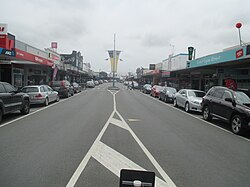 Victoria Street in Dargaville (2015) | |
| Motto(s): Heart of the Kauri Coast | |
 Dargaville | |
| Coordinates: 35°56′18″S 173°52′18″E / 35.93833°S 173.87167°E / -35.93833; 173.87167 | |
| Country | New Zealand |
| Region | Northland Region |
| District | Kaipara District |
| Population (June 2018)[1] | |
| • Total | 5,180 |
| Postcode(s) | 0310 |
Dargaville (Māori: Takiwira) is a town in the North Island of New Zealand. It is situated on the bank of the Northern Wairoa River in the Northland region. The town is located 55 kilometres southwest of Whangarei.
The population was 4,251 at the 2013 Census, a decrease of 204 since 2006 and 282 from 2001.[2]
It is noted for the high proportion of residents of Croatian descent. The area around it is one of the chief regions in the country for cultivating kumara (sweet potato) and so Dargaville is known by many locals as the Kumara Capital of New Zealand.
Contents
1 History
2 Geography
3 Climate
4 Transport
5 Education
6 Notable people
7 See also
8 Notes
9 External links
History

Gumdigger statue at Dargaville
The town was named after timber merchant and politician Joseph Dargaville (1837–1896).[3] Founded[when?] during the 19th-century kauri gum and timber trade, it briefly[when?] had New Zealand's largest population.
The area became known for a thriving industry that included gum digging and kauri logging, which was based mainly at Te Kopuru, several kilometres south of Dargaville on the banks of the Northern Wairoa river. The river was used to transport the huge logs downstream to shipbuilders and as a primary means of transport to Auckland.
Geography

Boats moored near central Dargaville
The nearby Ripiro Beach has the longest unbroken stretches of sand beach in New Zealand, and is largely drivable from one end to the other. This beach is home of the famous local shellfish delicacy called the toheroa. Overexploitation in the 1950s and 1960s caused the population of the shellfish to decline enough that public gathering of the shellfish is now prohibited.[4]
Dargaville is also the gateway to the Waipoua Forest, a protected national park and home of the biggest specimens of Kauri tree in New Zealand, Tane Mahuta (Māori, meaning "Lord of the Forest") being chief amongst them.
Dargaville is situated by the Wairoa River, with boat moorings adjacent to the city centre. The river is tidal when it passes through Dargaville.
Climate
Köppen-Geiger climate classification system classifies its climate as oceanic (Cfb).[5]
| Climate data for Dargaville | |||||||||||||
|---|---|---|---|---|---|---|---|---|---|---|---|---|---|
| Month | Jan | Feb | Mar | Apr | May | Jun | Jul | Aug | Sep | Oct | Nov | Dec | Year |
| Average high °C (°F) | 23.6 (74.5) | 24 (75) | 23 (73) | 20.5 (68.9) | 17.8 (64) | 15.8 (60.4) | 15 (59) | 15.4 (59.7) | 16.3 (61.3) | 17.8 (64) | 19.7 (67.5) | 21.9 (71.4) | 19.23 (66.61) |
| Daily mean °C (°F) | 18.8 (65.8) | 19.1 (66.4) | 18.3 (64.9) | 16 (61) | 13.5 (56.3) | 11.8 (53.2) | 10.9 (51.6) | 11.4 (52.5) | 12.5 (54.5) | 13.9 (57) | 15.5 (59.9) | 17.3 (63.1) | 14.92 (58.86) |
| Average low °C (°F) | 13.9 (57) | 14.3 (57.7) | 13.6 (56.5) | 11.5 (52.7) | 9.2 (48.6) | 7.8 (46) | 6.8 (44.2) | 7.4 (45.3) | 8.7 (47.7) | 10 (50) | 11.2 (52.2) | 12.7 (54.9) | 10.59 (51.06) |
| Average precipitation mm (inches) | 73 (2.9) | 74.6 (2.94) | 88.5 (3.48) | 89.3 (3.52) | 114.7 (4.52) | 145.2 (5.72) | 126.8 (4.99) | 128.7 (5.07) | 102.3 (4.03) | 91.2 (3.59) | 81.8 (3.22) | 72.3 (2.85) | 1,188.4 (46.83) |
| Source #1: Climate Charts (altitude: 15m)[6] | |||||||||||||
| Source #2: Climate-Data.org (altitude: 22m)[5] | |||||||||||||
Transport

Hokianga Road, one of the main roads in Dargaville township
Dargaville is on the junction of State Highways 12 and 14.
North of the town, the Donnelly's Crossing Section railway was established to provide access to other logging activities. The first portion of this line was opened in 1889, it reached its greatest extent in 1923, and after operating isolated from the national rail network for decades, it was connected with the North Auckland Line by the Dargaville Branch in 1940. The Donnelly's Crossing Section closed in 1959, but the Dargaville Branch continues to operate today as a freight-only line, though its future is less than certain.
The area around Dargaville is now predominantly a farming region and supports extensive dairy, beef, and sheep farms, as well as a thriving plantation forest industry.
Other attractions are the Kai Iwi lakes some 25 kilometres north of the town, and Pouto Peninsula. Baylys Beach is the local beach, just 13 kilometres from the township, and offers over 90 kilometres of rugged west coast surf.
Education
Dargaville High School is a secondary (years 9-13) school with a roll of 528.[7] The school opened in 1921, but was destroyed by fire in 1937 and rebuilt the following year.[8]Dargaville Intermediate is an intermediate (years 7-8) school with a roll of 166.[9] Both schools have a decile rating of 3.
Dargaville Primary School and Selwyn Park School are contributing primary (years 1-6) schools with rolls of 401[10] and 128,[11] respectively. Dargaville Primary was established by 1877. In 1879, it had a roll of 16, which grew to 155 in 1899.[12] It has a decile rating of 4. Selwyn Park celebrates its 50th Jubilee in 2008.[13] It has a decile rating of 1.
St Joseph's School is a full primary (years 1-8) school with a decile rating of 3 and a roll of 114.[14] It is a state integrated Catholic school.[15]
All these schools are coeducational.
NorthTec polytechnic also has a campus in Dargaville.[16]
Notable people
Amelia Batistich, writer, was born here in 1905[17]
Robert Hornblow (1861–1937), the town's mayor from 1919 to 1925[18]
Dion Nash, New Zealand cricketeer, attended Dargaville High School
Mike Perjanik, musician, record producer and composer
Winston Peters, New Zealand politician and leader of the New Zealand First party, attended Dargaville High School
Mark Taylor, All Black
Frank Watkins, World War II RNZAF pilot
Mark Williams, singer and recording artist
See also
- Croatian New Zealanders
Notes
^ "Subnational Population Estimates: At 30 June 2018 (provisional)". Statistics New Zealand. 23 October 2018. Retrieved 23 October 2018..mw-parser-output cite.citation{font-style:inherit}.mw-parser-output q{quotes:"""""""'""'"}.mw-parser-output code.cs1-code{color:inherit;background:inherit;border:inherit;padding:inherit}.mw-parser-output .cs1-lock-free a{background:url("//upload.wikimedia.org/wikipedia/commons/thumb/6/65/Lock-green.svg/9px-Lock-green.svg.png")no-repeat;background-position:right .1em center}.mw-parser-output .cs1-lock-limited a,.mw-parser-output .cs1-lock-registration a{background:url("//upload.wikimedia.org/wikipedia/commons/thumb/d/d6/Lock-gray-alt-2.svg/9px-Lock-gray-alt-2.svg.png")no-repeat;background-position:right .1em center}.mw-parser-output .cs1-lock-subscription a{background:url("//upload.wikimedia.org/wikipedia/commons/thumb/a/aa/Lock-red-alt-2.svg/9px-Lock-red-alt-2.svg.png")no-repeat;background-position:right .1em center}.mw-parser-output .cs1-subscription,.mw-parser-output .cs1-registration{color:#555}.mw-parser-output .cs1-subscription span,.mw-parser-output .cs1-registration span{border-bottom:1px dotted;cursor:help}.mw-parser-output .cs1-hidden-error{display:none;font-size:100%}.mw-parser-output .cs1-visible-error{font-size:100%}.mw-parser-output .cs1-subscription,.mw-parser-output .cs1-registration,.mw-parser-output .cs1-format{font-size:95%}.mw-parser-output .cs1-kern-left,.mw-parser-output .cs1-kern-wl-left{padding-left:0.2em}.mw-parser-output .cs1-kern-right,.mw-parser-output .cs1-kern-wl-right{padding-right:0.2em} For urban areas, "Subnational population estimates (UA, AU), by age and sex, at 30 June 1996, 2001, 2006-18 (2017 boundaries)". Statistics New Zealand. 23 October 2018. Retrieved 23 October 2018.
^ 2013 Census QuickStats about a place:Dargaville
^ Discover New Zealand:A Wises Guide (9th ed.). 1994. p. 15.
^ Carbery, Sara. "Te Kaitiaki Toheroa". Retrieved 1 August 2018.
^ ab "Climate: Dargaville - Climate graph, Temperature graph, Climate table". Climate-Data.org. Retrieved 2014-01-23.
^ "Dargaville, New Zealand: Climate, Global Warming, and Daylight Charts and Data". Climate Charts. Retrieved 2014-01-23.
^ "Te Kete Ipurangi - Dargaville High School". Ministry of Education.
[permanent dead link]
^ Ryburn, Wayne (1999). Tall Spars, Steamers & Gum. Auckland, N.Z.: Kaipara Publications. p. 165. ISBN 0-473-06176-7.
^ "Te Kete Ipurangi - Dargaville Intermediate". Ministry of Education.
[permanent dead link]
^ "Te Kete Ipurangi - Dargaville Primary School". Ministry of Education.
[permanent dead link]
^ "Te Kete Ipurangi - Selwyn Park School". Ministry of Education.
[permanent dead link]
^ Ryburn, p 222
^ "Selwyn Park School, Dargaville 50th Jubilee" (– Scholar search). Education Gazette New Zealand. 86 (8). 21 May 2007.
[dead link]
^ "Te Kete Ipurangi - St Joseph's School, Dargaville|St Josephs School". Ministry of Education.
[permanent dead link]
^ "Principal's Message". St Joseph's School. Archived from the original on 2008-10-14.
^ "Dargaville". NorthTec. Archived from the original on 5 June 2009. Retrieved 4 March 2010.
^ Obituary: Amelia Batistich, 2004, Life & Stylem NZ Herald News, Retrieved 30 April 2016
^ "Mr R. E. Hornblow". The New Zealand Herald. LXXIV (22866). 22 October 1937. p. 14. Retrieved 7 September 2016.
External links
| Wikimedia Commons has media related to Dargaville. |
| Wikivoyage has a travel guide for Dargaville. |
- Dargaville online portal
Coordinates: 35°56′S 173°53′E / 35.933°S 173.883°E / -35.933; 173.883


