Trier-Saarburg
Trier-Saarburg | ||
|---|---|---|
District | ||
| ||
 | ||
| Country | ||
| State | Rhineland-Palatinate | |
| Capital | Trier | |
| Area | ||
| • Total | 1,101 km2 (425 sq mi) | |
| Population (31 December 2017)[1] | ||
| • Total | 148,532 | |
| • Density | 130/km2 (350/sq mi) | |
| Time zone | UTC+01:00 (CET) | |
| • Summer (DST) | UTC+02:00 (CEST) | |
| Vehicle registration | TR, SAB | |
| Website | trier-saarburg.de | |
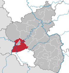
Trier-Saarburg (Luxembourgish: Landkrees Tréier-Saarburg) is a district in the west of Rhineland-Palatinate, Germany. Neighboring districts are (from the north and clockwise) Bitburg-Prüm, Bernkastel-Wittlich, Birkenfeld, Sankt Wendel (Saarland), and Merzig-Wadern (Saarland). To the west it borders Luxembourg. The district-free city Trier is completely surrounded by the district.
Contents
1 History
2 Geography
3 Museums
4 Coat of arms
5 Towns and municipalities
6 References
7 External links
History
The district was created in 1969 by merging the previous districts Trier and Saarburg.
Geography
The main river in the district is the Moselle. The area between its tributaries, the Ruwer and the Saar, is also well known as one of the prime wine regions of Germany.
Museums
Roscheider Hof Open Air Museum, Konz
- Fell Exhibition Slate Mine
- Air museum, Hermeskeil
- Railway and steam engine museum, Hermeskeil
Coat of arms
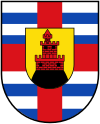
 | The coat of arms largely resembles the coat of arms of the Saarburg district. The castle in the middle shows the castle of Saarburg, even though now only the ruins of the castle remains. The red cross is the cross of Trier, as a large part of the Saarburg district (as well as of the new Trier-Saarburg district) historically belonged to the state of Trier. The blue bars were added after the merging with the Trier district, and symbolize that part of that district historically belonged to Luxembourg. |
Towns and municipalities
Verbandsgemeinden | |||
|---|---|---|---|
|
|
|
|
1seat of the Verbandsgemeinde; 2town | |||
References
^ "Bevölkerungsstand 2017 - Gemeindeebene". Statistisches Landesamt Rheinland-Pfalz (in German). 2018..mw-parser-output cite.citation{font-style:inherit}.mw-parser-output q{quotes:"""""""'""'"}.mw-parser-output code.cs1-code{color:inherit;background:inherit;border:inherit;padding:inherit}.mw-parser-output .cs1-lock-free a{background:url("//upload.wikimedia.org/wikipedia/commons/thumb/6/65/Lock-green.svg/9px-Lock-green.svg.png")no-repeat;background-position:right .1em center}.mw-parser-output .cs1-lock-limited a,.mw-parser-output .cs1-lock-registration a{background:url("//upload.wikimedia.org/wikipedia/commons/thumb/d/d6/Lock-gray-alt-2.svg/9px-Lock-gray-alt-2.svg.png")no-repeat;background-position:right .1em center}.mw-parser-output .cs1-lock-subscription a{background:url("//upload.wikimedia.org/wikipedia/commons/thumb/a/aa/Lock-red-alt-2.svg/9px-Lock-red-alt-2.svg.png")no-repeat;background-position:right .1em center}.mw-parser-output .cs1-subscription,.mw-parser-output .cs1-registration{color:#555}.mw-parser-output .cs1-subscription span,.mw-parser-output .cs1-registration span{border-bottom:1px dotted;cursor:help}.mw-parser-output .cs1-hidden-error{display:none;font-size:100%}.mw-parser-output .cs1-visible-error{font-size:100%}.mw-parser-output .cs1-subscription,.mw-parser-output .cs1-registration,.mw-parser-output .cs1-format{font-size:95%}.mw-parser-output .cs1-kern-left,.mw-parser-output .cs1-kern-wl-left{padding-left:0.2em}.mw-parser-output .cs1-kern-right,.mw-parser-output .cs1-kern-wl-right{padding-right:0.2em}
External links
| Wikimedia Commons has media related to Landkreis Trier-Saarburg. |
Official website (German)
| Urban districts |
|
|---|---|
| Rural districts |
|
Coordinates: 49°40′N 6°40′E / 49.67°N 6.67°E / 49.67; 6.67
Authority control |
|
|---|


