Khumbu

Map of the Khumbu region
Khumbu (also known as the Everest Region)[1] is a region of northeastern Nepal on the Nepalese side of Mount Everest. It is part of the Solukhumbu District, which in turn is part of the Sagarmatha Zone.[2] Khumbu is one of three subregions of the main Khambu (specially Kulung) and Sherpa settlement of the Himalaya, the other two being Solu and Pharak. It includes the town of Namche Bazaar as well as the villages of Thame, Khumjung, Pangboche, Pheriche and Kunde. The famous Buddhist monastery at Tengboche is also located in the Khumbu.[3]
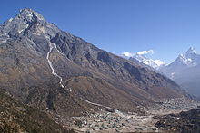
The Khumbila mountain rising above Khumjung and Kunde, two of the larger villages in the area, with Mount Everest, Lhotse and Ama Dablam in the background.

Khumbu Glacier
The Khumbu's elevation ranges from 3,300 metres (11,000 feet) to the 8,848 m (29,029 ft) summit of Mount Everest, the highest place on Earth.[4]
The Khumbu region includes both Sagarmatha National Park (above Monju) and the Sagarmatha National Park Buffer Zone, between Lukla and Monju.[2]
The Khumbu is a glacier believed to be the result of the last great Ice Age, ~500,000 years ago.
Lonely Planet has ranked Khumbu region in sixth best region in the world to travel.[5]
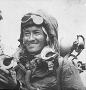
Tenzing Norgay, 1953 who was born in Khumbu region of Solukhumbu District
Villages in the Khumbu region
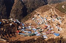
Village of Namche Bazaar
- Dingboche
- Kunde
- Khumjung
- Lobuche
- Lukla
- Namche Bazaar
- Tengboche
- Phortse
- Thame
- Thamo
- Pangboche
- Phakding
- Monjo
References
^ Khumbu Everest region
^ ab Bradley, Mayhew; "Trekking in the Nepal Himalaya"; (2009); 9 edição; pp 84-141; Lonely Planet; .mw-parser-output cite.citation{font-style:inherit}.mw-parser-output q{quotes:"""""""'""'"}.mw-parser-output code.cs1-code{color:inherit;background:inherit;border:inherit;padding:inherit}.mw-parser-output .cs1-lock-free a{background:url("//upload.wikimedia.org/wikipedia/commons/thumb/6/65/Lock-green.svg/9px-Lock-green.svg.png")no-repeat;background-position:right .1em center}.mw-parser-output .cs1-lock-limited a,.mw-parser-output .cs1-lock-registration a{background:url("//upload.wikimedia.org/wikipedia/commons/thumb/d/d6/Lock-gray-alt-2.svg/9px-Lock-gray-alt-2.svg.png")no-repeat;background-position:right .1em center}.mw-parser-output .cs1-lock-subscription a{background:url("//upload.wikimedia.org/wikipedia/commons/thumb/a/aa/Lock-red-alt-2.svg/9px-Lock-red-alt-2.svg.png")no-repeat;background-position:right .1em center}.mw-parser-output .cs1-subscription,.mw-parser-output .cs1-registration{color:#555}.mw-parser-output .cs1-subscription span,.mw-parser-output .cs1-registration span{border-bottom:1px dotted;cursor:help}.mw-parser-output .cs1-hidden-error{display:none;font-size:100%}.mw-parser-output .cs1-visible-error{font-size:100%}.mw-parser-output .cs1-subscription,.mw-parser-output .cs1-registration,.mw-parser-output .cs1-format{font-size:95%}.mw-parser-output .cs1-kern-left,.mw-parser-output .cs1-kern-wl-left{padding-left:0.2em}.mw-parser-output .cs1-kern-right,.mw-parser-output .cs1-kern-wl-right{padding-right:0.2em}
ISBN 978-1-74104-188-0.
^ Bonington, Chris; Everest, The Hard Way; (1977); pp 72-75; Arrow Books editions;
ISBN 0-09-915940-6.
^ Boukreev, Anatoli; The Climb;(1988); St. Martin's edition;
ISBN 0-312-96533-8.
^ http://www.lonelyplanet.com/best-in-travel/regions/06-khumbu?detail=1
External links
 Khumbu travel guide from Wikivoyage
Coordinates: 27°49′N 86°43′E / 27.817°N 86.717°E / 27.817; 86.717


